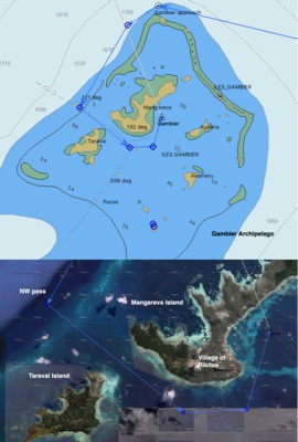
The Gambier archipelago consists of a diamond shaped reef, 15 miles across, located in the south-easternmost reach of French Polynesia. Within the reef is a calm lagoon with 6 islands and several islets.
There are 2 main reef passes to enter the lagoon. In the south, the reef is actually submerged to at least 30 feet, which means access into the lagoon can be made anywhere in that quadrant. Furthermore, waves enter the lagoon from the south.
In the north, the barrier reef is well-formed, with areas that are very shallow, and other areas containing strips of land called “motus” — these are sandy islets with occasional vegetation. There is a “false pass” in the NE corner (too shallow) and a “real pass” in the NW corner (good depth).
Since the wind was blowing from the north, we chose the pass in the NW corner, which is well marked by navigation buoys. Naturally, this being a territory of France, the color indicators on the buoys were backwards! Whereas in the United States, the adage is “Red-Right-Returning” – keep Red buoys on your Right as you’re Returning from Sea – here the red buoys must be kept on the left.
According to the lore we heard (from our Master Mariner Spencer) this reversal occurred during the war of 1812 when Britain attempted to reclaim America as theirs. The willy Americans flipped the buoy colors leading into all their bays, which caused the British battle ships to flounder on the rocks. America kept this reversed buoy system, which was adopted by many countries, whereas the original system is still used in many parts of the “Old World”.
Because of Gambier’s latitude (23 degrees south), it is influenced by the low pressure systems moving in the “Roaring Forties” (around 40 degrees south). The easterly trade winds are common in the summer, but currently we’re in the autumn (April-May), leading into winter (June-August). During winter there are many fronts with rain and cool weather, including northerly and westerly winds.
The cooler air of this latitude means that a mix of tropical and temperate trees are found on the islands, including pine trees, as we saw earlier in Pitcairn. In comparison with Adamstown’s 40 inhabitants, we heard that around 1400 people live in Gambier. The main industry appears to be pearl farming; tourism is very minor.
The photo shows the rough outlines of Gambier and a satellite view of Mangareva and Taravai islands, the two largest in the archipelago. The main village and anchorage is Rikitea, where we will go first to check in to the country.